          |
|
|
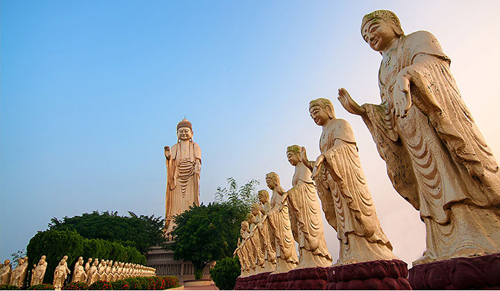
Kaohsiung A thriving international metropolis at the southern tip of Taiwan, Kaohsiung was the host city for the 2009 World Games. Due to the regulating effects of the marine climate, Kaohsiung is generally sunny and enjoys pleasant weather year-round. Known as "Taiwan's Maritime Capital," the city has worked hard in recent years to develop its tourism industry, including through beautification of the urban landscape. Kaohsiung is home to several popular visitor sites, including the Love River, Shoushan (Mt. Shou), Xiziwan Bay, Lotus Pond, Qijin, and the Old City of Zuoying. It also is an ethnic melting pot, joining Hokkien and Hakka communities, the Pingpu, Tsou, Rukai, Bunun, and Paiwan indigenous tribes, and a military community culture. Kaohsiung also offers scenic mountains, ocean views, and rivers, as well as port, cultural, and historic attractions. Visitors to the city can experience the beauty of nature and savor fine cuisine, or head to the nearby Hakka village of Meinong to experience traditional oil paper umbrella art. The Neimen Songjiang Battle Array and the Fo Guang Shan Buddhist monastery in Dashu further add to the ethnic richness of Kaohsiung. Taiwan's biggest mall and well-known night markets complete the scene for a thoroughly satisfying trip.  Fo Guang Shan Fo Guang Shan has a 4-hall main building and thousands of holy statues, and large and small halls of the Buddha which extend across the mountain. Solemn and forceful, with an imposing atmosphere, it is an important centre of faith in Taiwanese Buddhism. In addition to providing a diverse environment in which the public can pray and theological education can be provided, it is also a popular scenic spot, a site of pilgrimage for tourists. When the sun sinks in the west, the great Buddha statue and palatial temples, drenched in evening mist and bathed in sunlight, became yet more stately and vast, enough to make one forget the troubles of mortal life.1  Purple Crow Butterfly Valley
Maolin in Kaohsiung is an important habitat for purple butterflies, and by the most conservative estimate, millions of Purple Crow Butterflies glide here on purple wings, coming to the warm, sheltered mountain valleys of southern Taiwan, forming an overwintering group, "Purple Crow Butterfly Valleuy" whose members exceed 1 million in number. The butterfly trail is behind the Maolin National Scenic Area Administration, and the morning is the best time to see the butterflies.2  National Heritage Site - the Jhuzihmen Hydro Plant
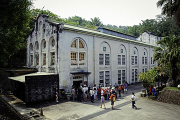
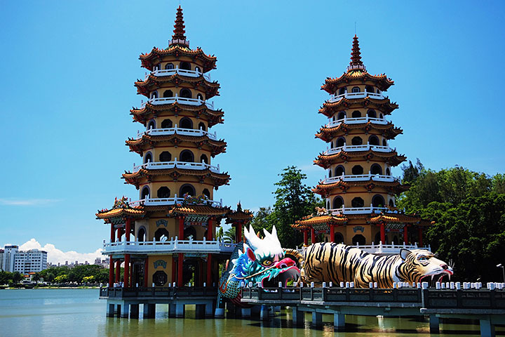
The Jhuzimen Hydro Plant, officially named the "Kaohsiung -Pingtung Power Plant Jhuzihmen Sub-Plant", was constructed to provide power for southern Taiwan in the Japanese Colonial Era (1908). The decision to house the plant inside a three-story imitation Baroque building meant that the power plant lacks a cold operating style, but it has gained a classical mildness. This is Taiwan's first "industrial heritage site", and was declared a national heritage site in 2003.3 Lianchitan (Lotus Pond) Scenic Area Lianchitan (Lotus Pond) Scenic Area is one of Kaohsiung's most traditional scenic areas, and was listed as one of the "Eight Sights of Fongshan" in the Qing Dynasty. There are pavilions by the beach, massive statues of gods and the "old city", surrounded by the city wall, living settlements such as historical sites, old houses, and military dependents' villages and you can also sample Zuoying's rich, diverse food in the old streets and traditional markets. The Longhu Tower (Dragon Tiger Tower) is the most famous scenic spot in Lianchitan. Constructed in 1976, the tower is seven stories tall, and the dragon and tiger doors are its entrance and exit. Its walls are decorated with koji pottery, which represent proselytizing stories, from a variety of artists. The tower's body is connected the Nine-Turn Bridge (Jiuqu Bridge) and is set off by the lake. There is a rule when visiting the Longhu Tower: enter at the dragon's mouth and exit from the tiger's mouth; this will allow you to avoid bad fortune and enjoy good luck. You can enjoy a 360-degree view of Lianchitan's scenery.4   Tianliao Moon World
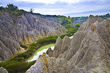
Tianliao Moon World is a tract of barren land between Chongde Village and Gutin Village of Tianliao District. It has a dreary and desolate beauty of desert and is famous for its similarity to the landscape of the Moon surface. This queer terrain is called "badlands" in geography an adverse landscape caused by the strong erosion of rain and streams over the years due to "rejuvenation" of the earth's crust. The Tianliao Moon World sits in the valley of a small tributary of Erren River and used to have a dam for sediment storage to store water in the rain season. The sight of it was called "yue-jing-nong-tang" (Farm Pond on the Moon). However, the dam (farm pond) has been washed away over approximately a decade of time with the continuous scour of rain. Today, nothing but total desolation is what is left there.5
1content source: http://khh.travel/Article.aspx?a=6216&l=2&stype=1058&sitem=4114; image source: http://eng.taiwan.net.tw/m1.aspx?sNo=0002121&id=2206
2content & image source: http://khh.travel/Article.aspx?a=6849&l=2&stype=1058&sitem=4112 3content & image source: http://khh.travel/Article.aspx?a=6211&l=2&stype=1058&sitem=4113 4content source: http://khh.travel/Article.aspx?a=6891&l=2&stype=1058&sitem=4112; image source: http://eng.taiwan.net.tw/m1.aspx?sNo=0002121&id=R157 5content & image source: http://eng.taiwan.net.tw/m1.aspx?sNo=0002121&id=631 |